Top 8 Hidden Travel Spots Found Through Photo Analysis
Published on May 2, 2025 • 20 min read
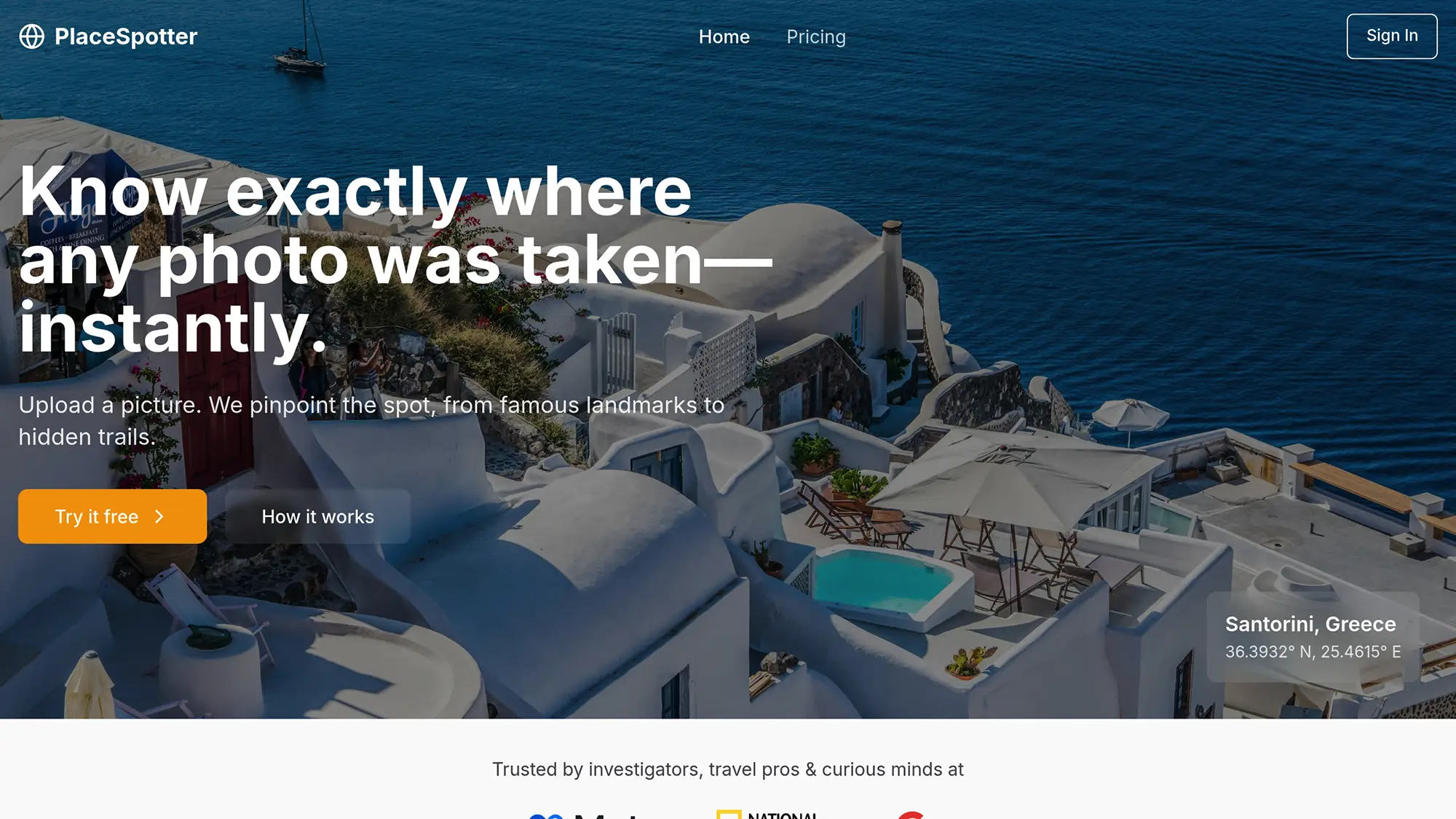
AI-powered photo analysis is transforming how we discover hidden travel destinations. By analyzing details like architecture, natural features, and metadata, these tools help pinpoint lesser-known spots worldwide. Here are 8 incredible locations identified through this technology:
- Fairy Pools, Scotland: Crystal-clear pools with a dramatic mountain backdrop.
- Huacachina Oasis, Peru: A desert oasis surrounded by massive sand dunes.
- Door to Hell, Turkmenistan: A fiery, glowing gas crater in the Karakum Desert.
- Vaadhoo Island, Maldives: Home to the bioluminescent "Sea of Stars."
- Chefchaouen, Morocco: A striking blue-painted city in the Rif Mountains.
- Marble Caves, Chile: Stunning blue marble formations on General Carrera Lake.
- Lake Hillier, Australia: A pink saltwater lake contrasting with the ocean.
- Antelope Canyon, USA: Iconic sandstone slot canyons with mesmerizing light beams.
These spots showcase how AI tools like PlaceSpotter can uncover hidden gems, providing precise geolocation and photography tips while respecting user privacy. Whether you're planning your next trip or searching for unique photo locations, these destinations are worth exploring.
🚀 AI Travel Hacks: Find Hidden Gems & Avoid Tourist Traps ...
How Photo Analysis Finds Hidden Places
Photo analysis technology is making it easier for travelers to discover lesser-known destinations. Using AI-powered tools, these systems identify locations from travel photos by combining three main technical processes:
- Visual Analysis: AI examines specific details in the image, such as architectural styles or natural features.
- Landmark Recognition: The system matches visual elements in the photo with a large database of known landmarks.
- Metadata Processing: Embedded data like GPS coordinates and timestamps help verify and refine location accuracy.
When a photo is uploaded, these components work together to pinpoint the location while keeping user privacy intact.
"We use a combination of AI visual analysis, landmark recognition, and metadata processing to identify locations with high accuracy." - PlaceSpotter [1]
To protect privacy, the system discards the original photo after processing. It only keeps small previews in a personal gallery, which users can delete anytime. This ensures sensitive data is secure while still allowing the technology to detect subtle details from underexplored spots.
"Original photos are processed and discarded after analysis. Small previews are stored in the personal gallery and you can remove them at any time. All your data is protected by state of the art encryption." - PlaceSpotter [1]
1. The Fairy Pools, Isle of Skye, Scotland
The Fairy Pools are a stunning natural attraction, known for their crystal-clear waters and vibrant aqua and teal colors. Set against the dramatic Black Cuillin mountains, they offer a breathtaking backdrop for photography and exploration.
Key Features
The Fairy Pools are easily recognized by:
- Clear waters cascading over dark, rugged rocks
- The striking silhouette of the Cuillin mountain range in the background
- Naturally formed pools that invite visitors to wade or swim
Getting There from the US
Fly into either Glasgow International (GLA) or Edinburgh (EDI). From there, rent a car or take public transportation through Inverness to reach the Isle of Skye. Once on the island, you'll find plenty of tips and guides to enhance your visit.
Travel Details
Located near Carbost and about 20.5 miles from Portree, the Fairy Pools are accessible via a moderate 1.5-mile round trip hike, which typically takes between 40 and 90 minutes. A newly upgraded parking lot with 120 spaces makes access more convenient.
Best Times to Visit
Take the single-track road from the B8009 carefully to reach the pools. Visiting early in the morning or late in the afternoon not only provides the best lighting for photos but also helps you avoid larger crowds. Use postcode IV47 8TA for GPS navigation.
Photography Tips
For capturing the beauty of the Fairy Pools, try these techniques:
- Shoot in the early morning for soft, reflective light on the water
- Use long exposure settings to emphasize the movement of waterfalls
- Frame wide-angle shots to include the majestic Cuillin mountains
- Zoom in to highlight the intricate rock formations around the pools
If you're planning to use a drone, remember that UK Civil Aviation Authority certification is required.
These details can help you plan your visit and make the most of your time exploring this incredible location.
2. Huacachina Oasis, Peru
Huacachina Oasis, tucked away in Peru's coastal desert, is the only natural oasis in South America. This 2-acre lagoon, fed by underground aquifers, is surrounded by massive sand dunes that create a stunning backdrop for photos[4]. Here’s how to get there from the U.S. and make the most of your trip.
Getting There from the U.S.
Fly into Lima's Jorge Chávez International Airport, then choose one of these options to reach Huacachina:
- Take a direct bus with Peru Hop, which takes about 4.5 hours[2][3].
- Use public transport: take a bus to Ica, followed by a short 3-mile taxi ride to the oasis[3][4].
- Rent a car in Lima and drive approximately 4.5 hours to the destination[3].
Once you arrive, you’ll find plenty to explore and enjoy.
Travel Planning Details
Huacachina is a small village with a population of around 100 people[4]. A 2-to-3-day stay is ideal for experiencing activities like sandboarding and dune buggy rides across the expansive dunes. The oasis is located just 3 miles (5 km) from the city of Ica.
Photography Tips
- Climb the dunes for sweeping panoramic shots.
- Take photos during golden hour to capture dramatic lighting and shadows.
- Include people or buildings in your shots to emphasize the scale of the landscape.
3. The Door to Hell, Turkmenistan
The Darvaza Gas Crater, also known as the "Door to Hell", is a massive, 230-foot-wide burning crater located in Turkmenistan's Karakum Desert. Its fiery glow and unique appearance make it a striking sight for visitors and photographers alike [5].
Key Photo Features
- A nearly perfect circular shape, spanning 230 feet in diameter
- Bright orange-red flames that burn continuously, visible day and night
- Surrounded by the barren, sandy terrain of the Karakum Desert
- Noticeable heat distortion, especially in nighttime images
These features make the crater a captivating subject for photography but also present unique challenges for travelers venturing to this remote location.
How It Came to Be
In 1971, a Soviet drilling operation accidentally punctured an underground gas cavern, causing the ground to collapse. To prevent the release of toxic gases, officials set the crater on fire, expecting it to burn out quickly. Over 50 years later, the flames are still going strong [5]. For U.S. travelers, understanding this history is important when planning a safe and informed visit.
Planning Your Trip
Visiting the Door to Hell requires careful planning, particularly for travelers from the U.S. Here’s what you need to know:
-
Visa Requirements
Turkmenistan's visa process can be tricky, so start early. Options include working with a licensed tour operator who can handle the paperwork, applying for a tourist visa with a Letter of Invitation (LOI), or, if applicable, using a transit visa for stays under seven days. -
Getting There
The easiest way to visit is by booking a multi-day tour, which typically costs around $500 per day. These packages usually cover transportation from major cities, camping gear for overnight stays, professional guides, visa help, and safety instructions.
Tips for Photographers
- Use a wide-angle lens to capture the crater’s size and the stark contrast of flames against the desert.
- Protect your camera from the intense heat with appropriate gear.
- Position yourself upwind to minimize heat distortion in your photos.
"What was an embarrassment to the Soviets is now a destination for adventurous visitors to Turkmenistan." [6] - Teresa Otto
Safety First
The crater’s unstable edges and intense heat mean safety is a top priority. Always follow your guide’s advice, stay at a safe distance, and if camping overnight, pack warm clothing to handle the desert’s chilly nights.
4. Vaadhoo Island, Maldives (Sea of Stars)
Vaadhoo Island’s Sea of Stars gained global attention after stunning photos went viral in 2013, leading to over 320,000 monthly Google searches worldwide [7]. This natural light show is a breathtaking example of nature’s ability to surprise and captivate.
The Science Behind the Glow
The glowing effect comes from marine plankton that emit "cold light" when disturbed. This bioluminescence is caused by a chemical reaction, with less than 20% of the light producing heat [8]. Marine biologist Lauren Arthur explains:
"When people say they want to see the Sea of Stars in the Maldives, they are actually asking to see a chemical reaction – it's bioluminescent plankton." [7]
Best Time to Visit
Plan your trip between April and October during the Southwest Monsoon for the best chance to see the phenomenon. Ismael "Issey" Naseer of Vaadhoo View Inn notes that bioluminescence can be spotted about 90% of the time throughout the year. For the clearest view, visit during a new moon when light pollution is minimal [7].
Getting There from the U.S.
Flights to Male International Airport (MLE) are available from major U.S. cities, with sample round-trip prices below:
| Departure City | Starting Price (Round Trip) |
|---|---|
| Dallas (DFW) | $1,371 |
| Chicago (ORD) | $6,321 (Business) |
| San Francisco (SFO) | $765 |
From Male, you can reach Vaadhoo Island via domestic flight or speedboat.
Photography Tips
To capture the Sea of Stars in all its glory:
- Use a high ISO setting and shoot manually during the darkest hours.
- Set up your tripod away from artificial light sources.
- Allow your eyes to adjust to the darkness for better visibility.
"It's like little diamonds underwater, and it's the most beautiful thing you will ever see."
- Lauren Arthur, marine biologist and wildlife presenter [7]
Insider's Advice
For a truly unforgettable experience, try night snorkeling when the plankton are thick in the water. As one expert put it:
"The best way to see it is to get into the water when it's thick with plankton and go night snorkeling. It's one of the most exciting things you can do." [7]
Why Vaadhoo Stands Out
Though bioluminescent plankton can be found in other parts of the world, Vaadhoo Island offers unmatched consistency and ideal conditions for photography, making it a top destination for witnessing the Sea of Stars.
5. Chefchaouen, Morocco (The Blue City)
Perched in Morocco's Rif Mountains at an elevation of 2,000 feet, Chefchaouen is famous for its striking blue color. Often called the "Blue Pearl" [10], this vibrant hue makes the city instantly recognizable in photos [9].
Historical Background
The city's iconic blue look traces back to the 1930s, when Jewish refugees brought the tradition of painting buildings blue. Lisa Trottier sheds light on this practice:
"Their choice of hue came from the Jewish tradition of weaving blue thread into prayer shawls to remind people of the sky, the heavens, and ultimately, God's power." [11]
What Stands Out in Photos
Chefchaouen’s unique architecture and design make it a photographer's dream. Here are key features to look for:
- Andalusian-style curved brick archways
- Traditional homes made from stone, brick, tile, wood, soil, and lime
- Narrow, winding alleys typical of the Medina
- Walls, doors, staircases, and archways all painted in varying shades of blue [9]
Traveling to Chefchaouen
Visiting Chefchaouen is straightforward, with several routes available from major Moroccan cities. Here’s a quick guide:
| From City | Distance | Drive Time |
|---|---|---|
| Tangier | 112.4 km (70 mi) | 2 hr 11 min |
| Tetouan | 64.9 km (40 mi) | 1 hr 26 min |
| Fez | 194 km (121 mi) | 3 hr 24 min |
A Unique Local Tradition
Every spring, residents receive paintbrushes from the local government to refresh the city’s blue-painted facades [11]. This effort is a community collaboration involving Berbers, Muslims, and descendants of Spanish exiles from the 15th century. These practices not only preserve the city’s charm but also make it a standout for photographers and AI recognition tools.
Photography Tips
To capture Chefchaouen’s charm:
- Shoot during early morning or late afternoon to make the most of the light and shadows in the narrow streets.
- Focus on details like archways to showcase Andalusian architectural influences.
- Highlight the various shades of blue to add depth and richness to your photos.
The city’s distinctive blue tones make it easily identifiable, both to travelers and AI tools, providing a perfect example of how unique visuals can spotlight hidden gems.
6. The Marble Caves, Chile
Located on General Carrera Lake, the Marble Caves showcase breathtaking blue reflections and intricate marble patterns. Shaped by waves over 6,200 years, these caves are one of South America's most picturesque hidden gems [12].
How They Were Formed
These caves, which date back 370 million years, feature:
- A series of caverns and tunnels carved out of solid marble
- Striking blue tones created by glacial silt interacting with light and water levels
- A location on General Carrera Lake, South America's fifth-largest lake
What Makes Them Stand Out
The caves are easy to recognize thanks to their smooth, curved walls and swirling patterns. Key formations, like the famous Capilla de Mármol (Marble Chapel), add to their charm. These natural features not only attract travelers but also challenge photo recognition technology with their complex designs.
Getting There from the U.S.
Here's a breakdown of the journey:
| Stage | Route | Duration |
|---|---|---|
| International Flight | U.S. to Santiago, Chile | 8–12 hours |
| Domestic Flight | Santiago to Balmaceda | About 2.5 hours |
| Ground Transport | Balmaceda to Puerto Río Tranquilo | Around 4 hours |
| Cave Access | Boat or kayak trip from Puerto Río Tranquilo | 1.5–3 hours |
When to Go
For the best experience:
- Peak Season: December through March
- Best Light for Photos: Early morning
- Most Vibrant Colors: September to February
- Packing Tips: Bring layers and a windbreaker to stay comfortable in changing weather.
Explorer Clemente Onelli, who documented the caves in 1896, once said, "South American Patagonia is one of the most magical places in the world."
The Marble Caves combine ancient geology with stunning natural light, making them a must-see destination for adventurers and photographers alike.
7. Lake Hillier, Australia (Pink Lake)
Lake Hillier stands out with its striking pink waters set against the deep blue of the ocean. Found on Middle Island off the coast of Western Australia, this small lake spans about 0.15 km² (0.06 mi²) and has become a favorite among photographers thanks to its unusual appearance. Its unique visual appeal has been confirmed through advanced photo analysis techniques often used to identify extraordinary natural locations.
Why Is the Lake Pink?
The lake's pink color comes from the presence of halophilic microorganisms. Two key contributors, Dunaliella salina and Salinibacter ruber, are responsible for the vibrant hue. Scientists have also used metagenomic studies to uncover more than 4,000 microbial species in the lake, including 249 halophilic species that thrive in salty environments [13].
Key Scientific Facts
| Feature | Data |
|---|---|
| Salt Concentration | 28% |
| Water Temperature | 79°F (26°C) |
| pH Level | 7.4 |
| Total Microbial Species | 4,000+ |
| Halophilic Species | 249 |
What Photo Analysis Reveals
Photo analysis has confirmed Lake Hillier's consistent pink color through detailed spectrum studies and geolocation markers. These advanced techniques also highlight unique features like the lake's coastline and surrounding vegetation, making it easier to pinpoint its exact location [13].
Photography Tips for Lake Hillier
If you're planning to photograph Lake Hillier, try these tips to make your shots stand out:
- Use a polarizing filter to cut down on glare.
- Shoot mid-morning for the best natural lighting.
- Include surrounding landscapes to give your photos depth and scale.
- Experiment with wide-angle shots and close-ups to showcase the lake's salt formations.
Lake Hillier's vibrant colors and unique environment make it an incredible destination for photographers and adventurers alike.
8. Antelope Canyon, Arizona, USA
Located within the Lake Powell Navajo Tribal Park near Page, Arizona, Antelope Canyon is one of the most photographed natural wonders in the world. This slot canyon, divided into the Upper and Lower sections, is famous for its stunning sandstone formations and mesmerizing light beams [14]. It's a prime example of how photo recognition can spotlight nature's intricate designs.
Distinct Features Captured in Photos
Antelope Canyon's unique beauty makes it stand out in photographs. Key features include:
- Smooth, flowing sandstone walls
- Sunlight streaming through narrow openings
- Vibrant color gradients that shift with the light
- Winding, narrow passageways with soft curves
Driving Distances from Major Cities
If you're planning a trip, here are the distances and travel times from nearby cities:
| Departure City | Distance | Drive Time | Notable Views Along the Way |
|---|---|---|---|
| Phoenix, AZ | 275 miles | 4.5–5 hours | Expansive desert scenery |
| Las Vegas, NV | 278 miles | 5 hours | Stops at Kanab and Lake Powell |
Travel Tips for Visitors
-
From Phoenix
Driving from Phoenix takes you through northern Arizona's arid landscapes. Stock up on water, snacks, and fuel before setting out, as service stations are sparse along the route. The drive offers endless desert views, so plan for a few scenic stops. -
From Las Vegas
The route from Las Vegas includes picturesque detours like Kanab and Lake Powell. If traveling during winter, watch for icy patches on higher-elevation roads and adjust your driving accordingly.
Tips for Photographers
Antelope Canyon is a dream location for photographers but comes with its challenges. The dance of sunlight and shadows across the canyon's smooth walls creates striking visuals, but capturing them requires careful timing. Both amateur and professional photographers are drawn to its surreal beauty, making it a frequent subject for creative exploration. This precision in capturing its essence mirrors the capabilities of AI tools discussed earlier in the article.
Photo Geolocation Tools Guide
PlaceSpotter's AI tools make travel discovery easier by pinpointing exact locations. Let’s break down its features, subscription options, and privacy measures.
Core Features
PlaceSpotter offers three key tools:
- Visual Analysis: Recognizes distinct geographical and architectural features in photos.
- Metadata Integration: Uses embedded data to improve location accuracy.
- Map Visualization: Pinpoints exact coordinates and provides detailed surroundings.
"PlaceSpotter helped me discover new locations for my photo shoots." - Stan S. [1]
Subscription Options
| Plan | Monthly Price | Photo Allowance | Features |
|---|---|---|---|
| Free | $0 | 3 photos | Basic location data |
| Lite | $4.99 | 30 photos | Detailed data; priority support |
| Pro | $9.99 | 200 photos | Commercial rights; priority support |
Credit Packages for Occasional Users
For those who don’t need a subscription, credit packages offer flexibility:
- 10 Credits: $2.00 (valid for 12 months)
- 100 Credits: $15.00 (valid for 12 months)
Privacy and Security
Your data is safe with advanced encryption during analysis. You also have full control over your gallery and content.
Professional Applications
These tools are a game-changer for professionals. For instance, photographer Alice S. found a hidden Bahamas location for a surprise party using PlaceSpotter [1].
Travel experts use the platform for:
- Scouting locations
- Verifying destinations
- Planning itineraries
- Finding hidden photo spots
Pair these tools with earlier insights to elevate your travel photography game.
Steps to Find Hidden Places with Photos
Here’s how you can use AI-powered photo analysis to uncover hidden spots with ease.
Choosing the Right Photos
Start by selecting high-quality images that showcase:
- Unique geological features
- Interesting architecture
- Distinct landscape patterns
- Recognizable vegetation or natural elements
Protecting Your Privacy
Did you know that 60% of iPhone users don't realize their photos often include GPS data [15]? Protect your privacy by managing location settings:
- For iPhone users: Turn off location tracking for the Camera app in Settings. For existing photos, use the Information button to remove location details.
- For Android users: Remove location data directly through the Share menu in your Gallery app.
Getting the Most Out of PlaceSpotter
PlaceSpotter’s tools make it easy to analyze and identify locations through photos. Here’s how to use it:
-
Upload Your Photo
Choose a high-quality JPEG, PNG, or HEIC image with a width of at least 1,000px. Avoid heavily filtered images for better results. -
Review the Results
Look for details such as:- GPS coordinates
- Location names
- Nearby landmarks
- Suggestions for similar locations
-
Verify the Information
Cross-check results with:- Local maps
- Seasonal changes in the area
- Accessibility and travel restrictions
"Knowing that this data exists and more importantly, how to remove this data from your photos is a step in protecting your personal information online." - Scott Eggimann, Technical Writer [15]
Staying Safe
Before sharing photos or planning visits, keep these tips in mind:
- Strip metadata from photos before sharing.
- Use secure methods to share images.
- Be aware of local privacy regulations.
- Consider cultural norms and sensitivities of the area.
Quick Reference for Your Workflow
Here’s a breakdown of the time you might spend at each stage:
| Phase | Action | Estimated Time |
|---|---|---|
| Research | Collecting photos | 30-60 minutes |
| Analysis | Processing images | 5-15 minutes/image |
| Verification | Cross-checking details | 15-30 minutes |
| Planning | Mapping out your route | 45-60 minutes |
Conclusion
AI-powered photo analysis is changing the way we discover travel destinations, offering insights through visual details and precise GPS data. This technology identifies locations that traditional guides might miss, opening up new possibilities for exploration.
By analyzing visual elements like landmarks, vegetation, and infrastructure, these tools can pinpoint locations even when geotags are absent. This makes it especially useful for finding less-traveled spots.
"From a privacy point of view, your location can be a very sensitive set of information" – Jay Stanley, Senior Policy Analyst at the American Civil Liberties Union
When using photo-based tools for travel planning, keep these tips in mind:
- Use clear, high-quality images with identifiable features for better results.
- Double-check location details from multiple sources before finalizing plans.
- Be mindful of privacy laws and cultural norms in the areas you visit.
- Account for seasonal conditions that could impact accessibility.
FAQs
How does AI-powered photo analysis ensure user privacy while uncovering hidden travel destinations?
AI-powered photo analysis prioritizes user privacy by focusing on publicly available data, such as metadata from shared images or geotagged photos, rather than accessing personal or private information. This ensures that the process respects individual privacy while identifying unique travel locations.
Additionally, these technologies often anonymize data and follow strict privacy protocols to prevent the misuse of sensitive information. By leveraging ethical AI practices, the focus remains on uncovering hidden gems without compromising user trust or confidentiality.
How can travelers use photo analysis tools responsibly while respecting privacy laws and cultural norms?
When using photo analysis tools to explore new destinations, it’s essential to act responsibly and respect local privacy laws and cultural practices. Avoid geotagging exact locations to help prevent overcrowding and protect sensitive areas or wildlife. Before photographing people, always ask for their permission and respect their preferences if they decline.
Be mindful of cultural sensitivities - avoid taking photos of sacred sites, ceremonies, or funerals without explicit permission. Additionally, exercise caution when photographing children, as privacy laws vary widely. By staying respectful and informed, you can enjoy your travels while honoring the communities you visit.